Green Transition Information Factory Kickstarter (UK-Ireland-France demonstrator)
Emeritus Prof. Jan-Peter Muller, UKIF Co-ordinator, Mullard Space Science Laboratory, University College London, Holmbury St. Mary, Surrey, RH5 6NT
email: j.muller@ucl.ac.uk
The global climate and sustainability crisis poses unprecedented challenges to humanity. Transitioning the global economy and societies towards a carbon neutral future, establishing a sustainable use of natural resources and ecosystems are key challenges that need to be addressed at various levels (e.g., policies, technology & innovation, culture & livelihoods) to succeed. This is known as the Green Transition and the provision of information systems and services as the Green Transition Information Factory (GTIF). The European Space Agency have funded 4 consortia to provide 5 services as kickstarters. This summarises the objectives of the UK, Ireland and France (UKIF) consortium.
The aims and objectives of this multi-national project (UK, IE, CA) are to demonstrate the use of Earth Observation (EO) and geospatial data for 5 Kickstarter applications each of which addresses challenges in each of 5 different domains: energy, mobility, sustainable cities, food systems and carbon accounting.
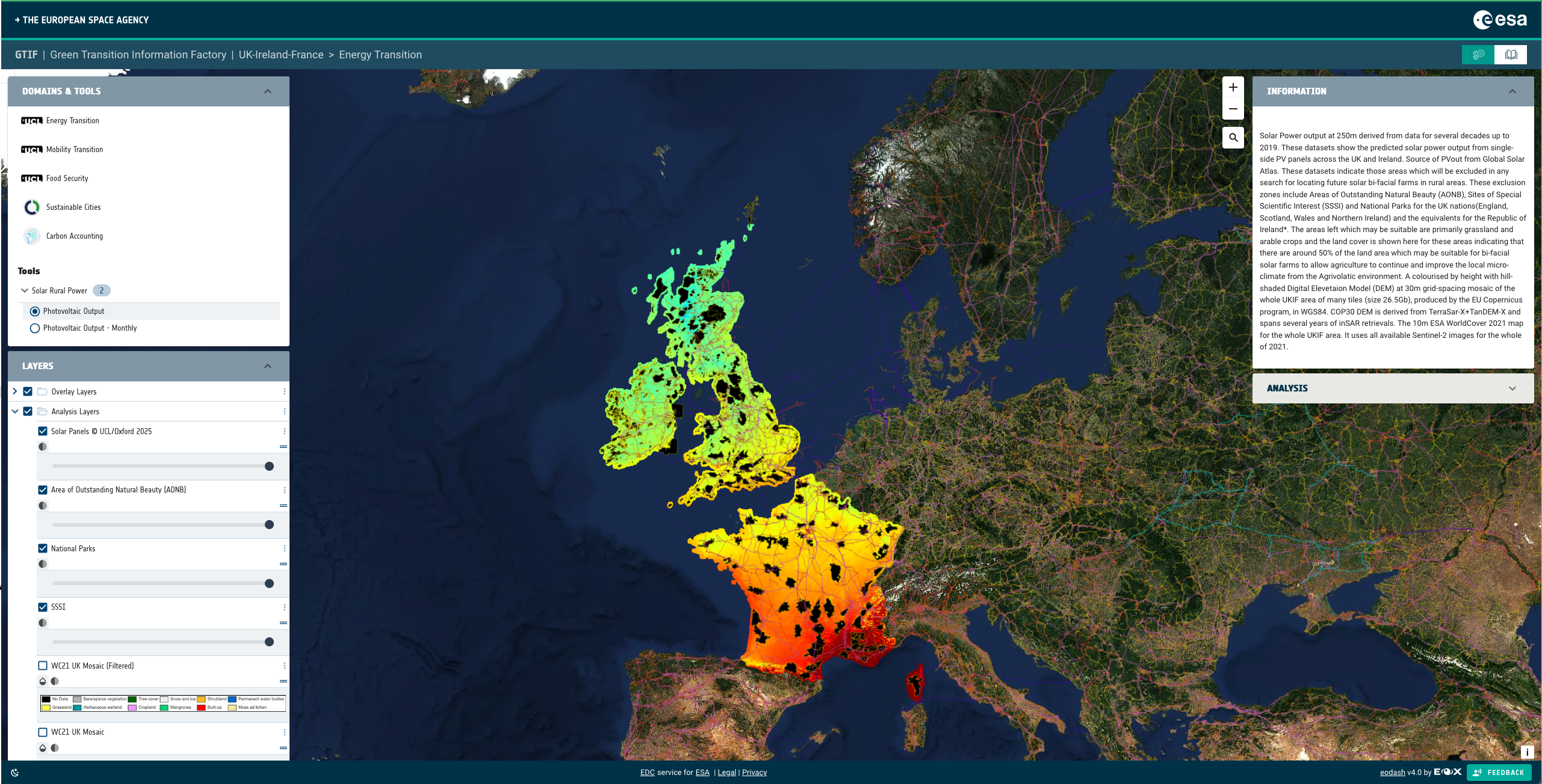
For energy, we have focused on solar power generation over rural areas. We provide a map of potential areas of interest suitable for the installation of bi-focal PhotoVoltaics to allow solar power generation on a massive scale whilst permitting "under panel" agriculture from livestock to crops. This might also be possible over trees which would have the advantage of fixing CO2 whilst generating solar energy power. This will employ the retrieval of 10m/20m surface albedo over existing LULC (Land Use Land Cover), terrain height, slope and aspect and its use in modelling solar power output from raised bfPV solar panel farms. Resolution enhancement will be employed to generate 2.5/5m albedo products.
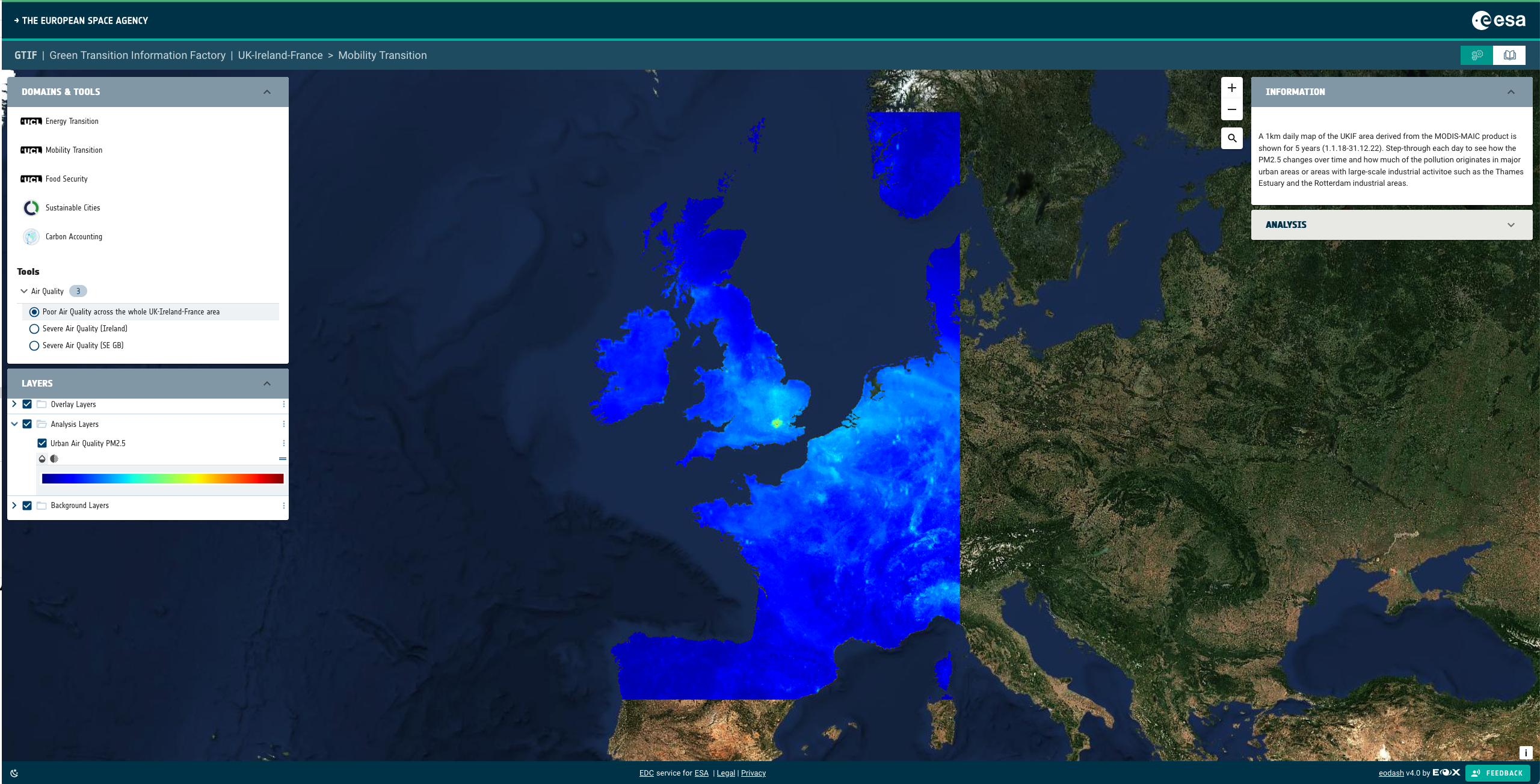
For mobility, we provide street-level atmospheric particulate pollution for particles of ?2.5µm (PM2.5) using resolution enhanced MODIS PM2.5 data at 250 metres, using the SIAC atmospheric correction scheme with BRDF models derived from VIIRS at 1km and, when available, Sentinel-3/OLCI at 300m. We employ existing in situ street-level PM2.5 data and machine learning to convert AOD (Aerosol Optical Depth) to street-level PM2.5. Resolution enhancement was employed to generate 2.5/5m PM2.5 products.
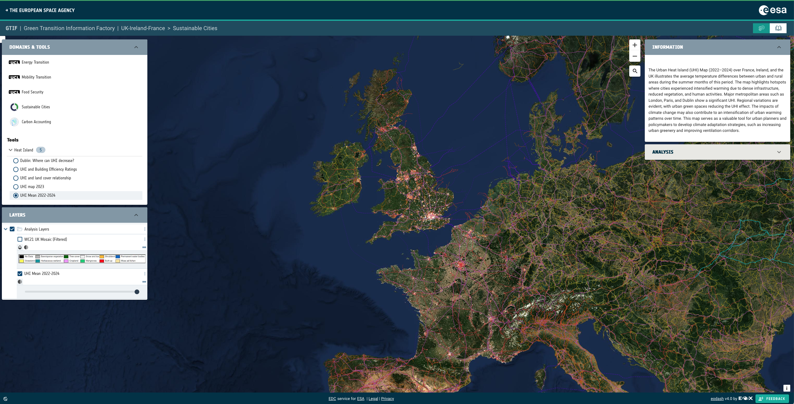
For sustainable cities, we mapped the thermal anomalies over the 2 areas of interest at 2 different resolutions using resolution enhanced maps of SUHI (Surface Urban Heat Islands) and SHL (Surface Heat Loss) on a per building block basis. Landsat-8/9 TIRS data with resolution enhanced from 100m to 25m was employed for the SUHIs and SatVu MWIR data for small targeted regions in urban areas with resolution enhanced from 3.5m to 1m was employed for the SHL maps.
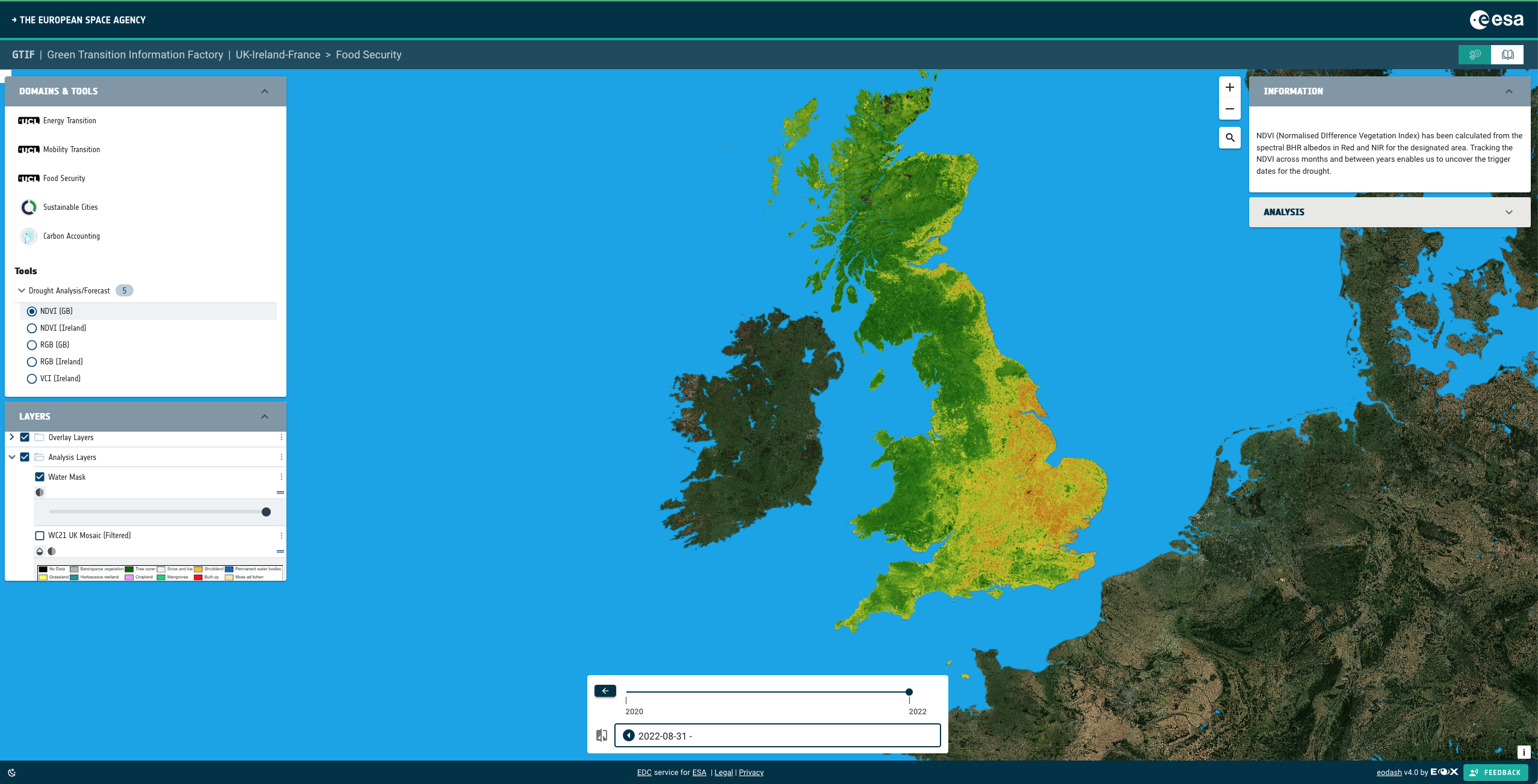
For food systems, we mapped drought occurrence using different methods from Sentinel-2 and Landsat-8/9 both in the VNIR as well as the TIR. This employs spectral VNIR & broadband albedo with resolution enhancement to generate 2.5m albedo products as well as various ratios, measures assessing large water body reductions.
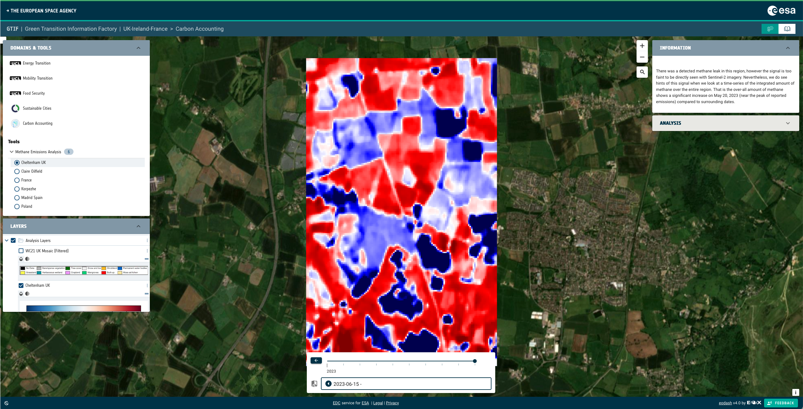
For Carbon accounting, we mapped fugitive emissions from both natural and anthropogenic (quantified into kg/sq.km.) from Sentinel-2 SWIR channels at 20m and later in the project from the EarthDaily constellation at 95m in dual SWIR channels. Resolution enhancement was employed to generate 5m methane emission maps every 5 days as well as 25m daily products from the EDC.
All of these products and associated services are mounted on a single platform and available through one unified UIX which includes simple modelling (e.g. how much solar power could have been generated on 15 July 2023 cf 15 July 2024 taking into account cloud cover and the underlying LULC). Processing had been done on existing free services such as the Copernicus Land Monitoring S2GM (Sentinel-2 Global Mosaics) Service, on cloud services and in-house at the partners. The platform had been developed by one partner on their own cloud service system. The ESA Network of Resources (NoR) is being used to store those products associated with all 5 capabilities and eventually generate them.
A stakeholder network has been created by another partner based initially on letters of support from representative national government ministries, regional and local government services in addition to private sector organisations in the financial services and renewable power industry. This stakeholder network is being used to build end user interest in the platform including defining the resolution, accuracy, reliability, and timeliness of the products. An evaluation by stakeholders is being made of the "fitness for purpose" and will be demonstrated at the final showcase in Jan/Feb 26 covering UK, Ireland and France.